Build the routes. In minutes, in the browser.
aryve Studio is where your team turns a 3D scan into a building that guides people: floors, walls, waypoints, lifts between floors, step-free journeys and AR content. It connects to the data you already have, from IMDF maps to the AODB. No code, no CAD software, just a browser.
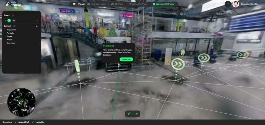
See the space the way you need to edit it.
Switch between a flat floor plan, the raw point cloud and two views made for routing. Every change is saved to the same digital twin.
Everything Guide needs to lead people the right way.
Floors
Floors are detected automatically from the scan. Adjust floor and ceiling heights, then generate the floor plan or upload your own.
Walls
Mark walls, barriers and restricted areas with wallpoints, so routes never lead through them.
Waypoints and paths
Draw a path in one go, or place waypoints and connect them automatically within a maximum distance. The shortest route is calculated from them.
Portals
Stairs, lifts, escalators and doors connect the floors. A weight tells the routing which crossing to prefer.
Journeys
Save routes such as a step-free way from the entrance to check-in, using lifts instead of stairs.
POIs and AR content
Destinations people can search for, in categories, each with an image, video or 3D object that appears in AR when they arrive.
Bring the maps and data you already have.
aryve Studio does not have to start from zero. Connect external sources to the digital twin, and keep routes and destinations current with live data.
IMDF files
Import the airport's Indoor Mapping Data Format files with units, openings and amenities, aligned to the scan.
Indoor map platforms
Use maps and POIs from the map provider you already work with, instead of drawing them twice.
AODB
Connect the airport operational database, so flights, gates and stands feed into destinations and routes.
Live data
Feed in live information such as gate changes, closures or detours, and every channel follows the update.
Small things, big difference on site.
Location from a phone scan
Upload a scan from the aryve Capture app and Studio creates the Location automatically, with floor plan, waypoints and default AR content.
Suggested waypoints
For E57 scans, Studio suggests waypoints and edges, so routing starts from a draft instead of a blank map.
Plan meets point cloud
Reference points align your floor plan with the 3D scan, so everything placed in 2D sits in the right spot in 3D.
Continuous floor changes
Per portal, choose whether passengers walk through without a stop or get a clear “change floor” screen.
Content that faces you
Images and videos can be fixed, billboard or always facing the camera. 3D objects can be animated.
Calls to action
Link a POI to a website, or trigger a 3D animation when a passenger taps it.
Draft, then publish
Keep POIs disabled until they are ready, and decide which ones appear as destinations. Save and undo included.
Public or private
Choose per Location whether it shows in aryve Guide, and add GPS coordinates to place it on the world map.
Edit a building you can recognise.
From the point cloud of the scan, aryve Studio can render the space as a Gaussian splat: a photorealistic 3D scene you can fly through. Shops, signs and doors look the way they do on site, so your team places waypoints and content without guessing.
- Recognise the space instead of reading dots
- Check routes from the passenger's point of view
- Explain the project to stakeholders who have never seen a point cloud
The splat is a viewing aid for people. Positioning runs on aryve Vision's own visual map.
A step-free airport route in minutes.
Watch our team build a step-free route at Paderborn/Lippstadt Airport in aryve Studio: walls, waypoints, a lift as portal between floors, and the finished journey on the 3D scene.
Video on YouTube. It loads only when you press play.

Put content exactly where it belongs.
Place a POI in the 2D or 3D editor with a right-click, choose its type and drag in the content. When a passenger arrives, aryve Guide shows it in AR at that exact spot: a welcome at the gate, an offer in front of the shop, an exhibit that comes to life.
More than an editor: the control room for every site.
Next to the map editor, aryve Studio manages everything behind a live installation.
Locations
All your sites in one overview, public or private, with their live status and who changed them last.
Scans
Every scan from the aryve Capture app or an E57 upload, with processing status, size, number of scan spots and floors.
Deployments
Start and stop the positioning for a site, manually or on a schedule, with autoscaling for peak hours.
Users and organisation
Invite your team and set who can view and who can edit each site.
Keyboard first
Fly through 3D with WASD, Shift for up and down, and place image, video or 3D content with the keys 1, 2 and 3.
Multi-floor by design
Switch floors with one click. Each floor keeps its own scan, plan, walls and content, connected by portals.
Days, not months.
Scan
With the aryve Capture app or a professional scanner (E57).
You or aryveLocation set up
Created automatically from an aryve Capture scan, or set up by aryve for E57 scans, with floors, point cloud and floor plans.
Automatic or aryveWalls and paths
Mark walls, place waypoints and portals between floors, or connect your IMDF and map data.
Your teamPOIs and content
Add destinations, journeys and AR content, and connect the AODB and live data.
Your teamLive in Guide
Every change is available in the app, the web app and the chat.
Instant
Made for the people who run the building.
Operations teams
Update routes for construction, gate changes or detours yourself, without waiting for a vendor.
Service providers
Set up staff-only routes and restricted zones for ground handling and assistance teams.
Project managers
Go from scan to live in days, with role-based access so only authorised people edit the map.
| Runs in | The browser on desktop. Best in Chrome; Firefox, Safari and Edge are supported |
| Scan input | aryve Capture app (automatic Location setup) or E57 from professional scanners |
| Data sources | IMDF files, indoor map platforms, AODB, live data feeds |
| Views | Floorplan, 3D (point cloud), Waypoint, Waypoint 3D |
| Content | Floors, walls, waypoints, edges, portals, journeys, POIs in categories |
| Media formats | JPG and PNG images, MP4 video, GLB 3D objects with animation |
| Used by | aryve Guide on every channel, and partner apps via API |
| Access | Role-based permissions, public or private Locations |
Questions about aryve Studio
Do we need technical skills to use aryve Studio?
No. Studio runs in the browser and works with right-clicks and drag and drop. Placing walls, waypoints and POIs takes minutes, as the video shows.
Can we use our existing maps and airport data?
Yes. aryve Studio can connect external data sources: the airport's IMDF files, maps from indoor map platforms and the AODB. Live data such as gate changes or closures can be fed in as well, so routes and destinations stay current.
Who sets up the Location?
With the aryve Capture app the Location is created automatically from the scan, with floors, floor plans and suggested waypoints. For scans from terrestrial scanners, the aryve team sets it up. Your team then customises walls, routes and content.
How do routes between floors work?
Lifts, escalators, stairs and doors are added as portals. Each portal has a target on the next floor and a weight that tells the routing which crossing to prefer, so step-free journeys can use lifts only.
What is the Gaussian splat for?
It renders the scan as a photorealistic 3D scene, so people can recognise the space while editing and explaining routes. Positioning itself runs on aryve Vision's visual map.
How fast do changes reach passengers?
Changes in Studio are saved to the digital twin and used by aryve Guide on every channel, from the app to WhatsApp.
Build your first route with us.
In 30 minutes we show you aryve Studio on a real terminal, look at the data you already have and sketch what your first zone would look like.